Uwharrie Trail Audio Tour

Thanks to the work of Life Scout Chris Moncrief, Land Trust intern Rebecca Schoonover, trail founder Joe Moffitt, and many other Uwharrie Trail and Three Rivers Land Trust partners and friends, the Uwharrie Trail now features an audio tour! Chris and his team installed QR posts at 24 spots along the trail. “We had no idea how mountainous this area was when we started this project,” Chris tells LandTrust staff. “It was a very challenging and rewarding experience.”

Chris Moncrief at Site 14[2]

In locations with cell phone service, hikers can scan the QR code with their smartphones and get a short story of what makes that spot so special. You can also download the stories beforehand and listen as you reach the sites, since some of the locations are out of cell phone reception for some providers.  The main goal of this project was to document some of the stories and folklore of the Uwharries using the Uwharrie Trail as the link, to celebrate a shared natural and cultural heritage and sense of place in this area that is special to so many people. So the next time you are hiking along the trail take time to stop and hear the story of unique glade communities, old firetowers, or the ghosts of settler’s past, and hopefully this experience will add to your enjoyment of the magic and beauty of our Uwharrie landscape.
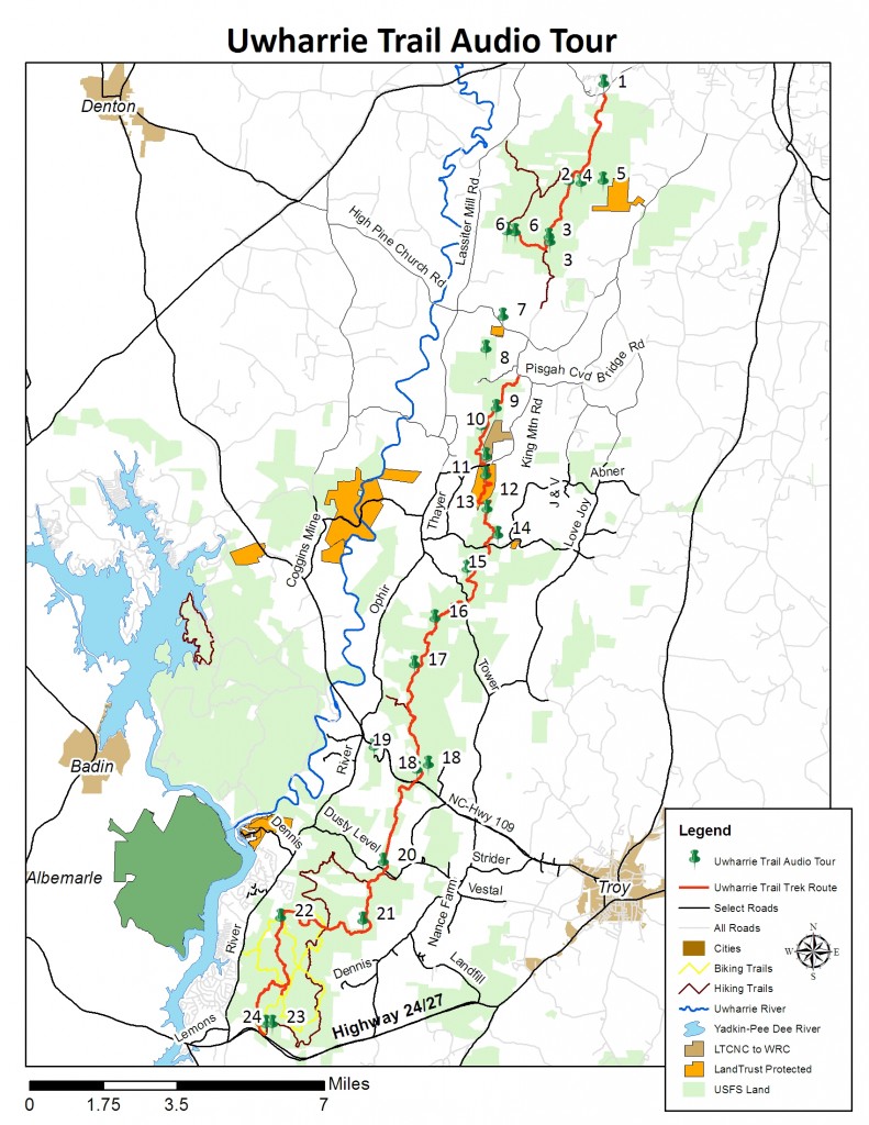

Photo:  Chris Moncrief at Audio Tour stop #14.


Audio Tour Stop

Name

Latitude

                 Longitude

1

Tot Hill Trailhead

35.63637698

-79.90463541

2

Camp 5

35.60254050

-79.91901247

3

Bingham Cemetary

35.58142606

-79.92676221

4

Bootleg Hollow

35.60199282

-79.91386807

5

Rush Mine

35.60271157

-79.90459534

6

Cooper Homesite & Graveyard

35.58458981

-79.94138687

7

McArthur Property

35.55546700

-79.94628300

8

Walkers Creek

35.54441996

-79.95325992

9

Camp 7 Rattlesnakes

35.52395177

-79.94881759

10

King Mountain

35.51763600

-79.95483300

11

Joe Moffitt Trailhead

35.50735300

-79.95279288

12

Little Long Mountain

35.50073348

-79.95296831

13

Diane Woodell Grave

35.48904232

-79.95223942

14

Jumpin Off Rock

35.48010400

-79.94751500

15

Dark Mountain

35.46833100

-79.96036700

16

Panther Branch

35.45139400

-79.97370300

17

Morris Mountain

35.43526900

-79.98232200

18

Highway 109 Trailhead

35.39884700

-79.98073300

18

Longleaf Pine Forest

35.40062200

-79.97601400

19

Buck Mountain Fire Tower

35.40666700

-79.99879400

20

Yates Place

35.36695300

-79.99456100

21

Dutchmans Creek

35.34646700

-80.00285800

22

Dennis Mountain

35.34730000

-80.03743300

23

Lawrenceville

35.31061600

-80.04046600

24

Conclusion Woodrun TH

35.31053600

-80.04345300

Contact

Phone

(704) 647-0302

Address

204 East Innes Street, Suite 120
Salisbury, NC 28144

Email

threerivers@threeriverslandtrust.org

Contact

Phone

(704) 647-0302

Address

204 East Innes Street, Suite 120
Salisbury, NC 28144

Email

threerivers@threeriverslandtrust.org