by Crystal Cockman
February 21, 2018
The LandTrust for Central NC hosted a hike at the Pee Dee National Wildlife Refuge on January 26. Greg Walmsley, Assistant Refuge Manager led us on a hike down to the Griffin Lowlands, an area that is closed off to the general public this time of year as a waterfowl sanctuary.
We gathered at the refuge office but drove to the Gaddy Covered Bridge and Trail. To get there, you go north from the refuge and turn on Grassy Island Road. You turn left at the refuge kiosk onto Griffin Road, then left onto Gaddy Road and the trail access is on the right. We parked along the road and then walked down the trail and under the bridge, which spans Thoroughfare Creek.
In summer months this is a ¾ mile loop trail, but in winter a portion of it is closed to the public. We were able to go past the signs that said area closed, and into an open field and wetland area. There was a huge oak tree in the distance, and ducks flying in every direction. We watched them from a distance, as most of them were pretty far away.
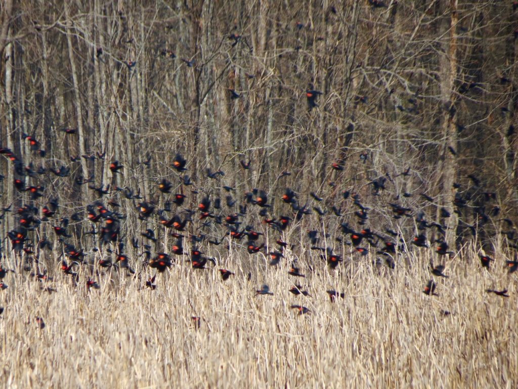
We saw mallards, wood ducks, gadwall, ringnecks, shovelers, and pintails. We also got to see a large flock of red-winged blackbirds, which made a whooshing sound as they flew up from the inundated cornfield to the trees nearby. Another neat sighting was of a northern harrier, or marsh hawk, which was standing in the gravel road we were walking down. He flew and flashed his white patch above his tail so that I knew what it was.
Greg told us at the Christmas Bird Count this year at the refuge, they got a record of a Golden Eagle. He said it was reliable because it was several experienced birders who were able to watch it for several minutes. Golden eagles are larger than bald eagles, and have a wingspan that is the fifth largest of all living eagle species. They can fly at speeds of up to 200 miles per hour.
There are two short hiking trails near the wildlife refuge office, and we didn’t have time to hike those the day of the event but I encourage any one who visits to check them out. One trail is about ¾ of a mile loop, and it goes over a nice boardwalk over a neat wetland, and then turns into the forest. You’ll go past some interesting rocky outcrops, possibly part of a diabase dike. Then the trail circles back around to the start by Sullivan Lake. The second trail is shorter, and also a loop. It is across the road from the refuge office. This trail follows Brown Creek for a ways, then loops back around through the field of switchgrass you see when you first enter the refuge. Many people also walk the gravel roads in the refuge, of which there are plenty to choose from. It’s also a great place to bike around.
There are plenty of interesting spots to check out in the refuge even if you didn’t join us for the special trip down to the lowlands. Come back in summer months and you can go down there, and there’s even a canoe put-in. It’s a four mile float from there to the Highway 109 Red Hill WRC boat access. PDNWR has lots to offer, so plan a trip or stop by next time you’re in the area and check it out.