by Crystal Cockman
July 6, 2018
 Several years ago, The Land Trust worked with the North Carolina Zoological Society to protect a property that adjoins High Pine Church Road that will become the Walkers Creek Trailhead on the Uwharrie Trail hopefully later this year. The acquisition of this tract makes it possible for the trail to be re-routed through the Walkers Creek section of U.S. Forest Service Land between High Pine Church Road and King Mountain Road. This results in approximately 2.1 miles of new trail.
The original alignment for this section of the Uwharrie Trail went from the Luther Place to Pisgah Covered Bridge Road and then north to cross over High Pine Church Road. With this reroute, the trail no longer continues on these state roads but instead goes north through the forest on a hiking trail.
The process for getting this new trail approved was quite lengthy and involved. To begin with, The Land Trust in partnership with the Uwharrie Trailblazers paid for an archeological study of the proposed trail corridor to make sure no historical resources would be disturbed by the creation of the new trail section. NC Zoo staff, Nell Allen and Moni Bates also performed a botanical survey to ensure no rare or endangered plants would be disturbed by the trail creation.
The proposed trail did have to be adjusted to avoid certain areas, but a route was found that would be acceptable and not disturb any archeological or botanical resources. Biological resources also had to be examined and a time period provided for the U.S. Fish and Wildlife Service to comment. The USFS archeologist also had to obtain concurrence from the State Historic Preservation office.
The public was given a time period to comment on the proposed location of the trail. On March 29, 2017 a scoping letter was sent to various user groups and advocacy groups including the project description and a map that could be circulated to members and posted on websites. The letter was also emailed out to other trail volunteers and participants in the trail strategy. Information was also placed on the National Forests in North Carolina’s schedule of proposed actions (SOPA). The SOPA is mailed to all persons who have expressed an interest in activities that occur on National Forests in North Carolina and is available on the Internet.
A Decision Memo providing approval to begin construction on the trail was signed by Michael Spisak, District Ranger on the Uwharrie National Forest, on April 27, 2018. Trail construction could begin on May 12, 2018. In addition to the reroute of the trail, the decision memo letter indicated that an additional 5.6 miles of trail are to be added to the Uwharrie National Recreational Trail on lands recently transferred to the U.S. Forest Service from The Land Trust. This trail already existed before transfer and was reclaimed by volunteers since 2013. An existing 0.5-mile connector trail, the Luther Spur, was also added to the trail system on the Uwharrie National Forest. The project also includes the addition of the Joe Moffitt Trailhead on Thayer Road and the trail shelter on top of Little Long Mountain to the Uwharrie National Forest infrastructure.
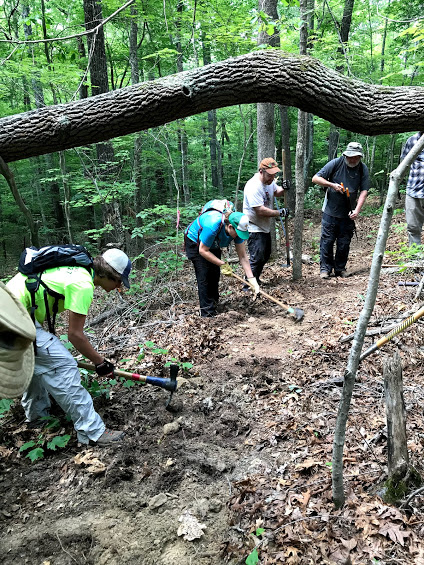
The first official trail workday held by the Uwharrie Trailblazers was on June 9th. For this first workday, 39 people came out to help begin building this much-awaited section of trail. This was the largest workday this group has seen to date. Many faithful volunteers showed up who have come to other workdays, as well as new faces. A cookout followed the workday to celebrate the commencement of building this new stretch of trail.
Workdays will continue on second Saturdays of the month starting in August. Please come out and help us build this exciting new section of the Uwharrie Trail! For more information you can contact The Land Trust at www.landtrustcnc.org or 704-647-0302 or the Uwharrie Trailblazers at uwharrietrailblazers.org or uwharrietrailblazers@gmail.com.